|
|
|
|
|
|
|
|
|
|
|
|
|
|
|
|
|
|
|
|
Introduction
back
to top |
The first site of its type narrating the history of a phase
continuing to be lived in Lebanon, the country of culture,
civilization, and history, Mleeta is a terrestrial and
sub-terrestrial museum aimed at closely identifying the
unique experience of the Islamic resistance in Lebanon
against the Israeli enemy from the beginning of the
occupation of Lebanon’s capitol, Beirut, in 1982.
60 000 m2 of parks and bushy lands, 4500 m2 of built spaces
overseen by over 50 architects and engineers and 40
specialists and 90 suppliers all formed an active workgroup
from all over Lebanon, continuously overseeing all aspects
of the project around the clock for over 2 years.
The site was named Mleeta after the mountain it is situated
on, where resistance fighters were stationed throughout the
years of the Israeli occupation till the year 2000 when most
parts of Lebanon were liberated. Mleeta was one of the first
lines of defense in a wide area including Nabatiyeh, Jizzeen,
Iqlim al-Tuffah, and was a base for launching various jihadi
operations inside the occupied security zone.
|
|
Sections
back
to top |
1. Parking: with space for 200 vehicles and 20 busses.
2. Site Entrance: consists of the ticket booth and the main
gate through which visitors pass on foot towards the
concrete arc which sums the architectural theme of the site.
3. Mleeta Souvenirs / Gift Shop: a corner selling gifts and
special souvenirs.
4. Prayer Corner/Place: space for 250 people to pray; it has
separate entrances for ladies and men and individual
ablution areas.
5. Administrative Building: consists of administrative
offices and a guests’ salon.
6. The Square: Main square serving as a gathering point for
visitors with access to site divisions.
7. Hall Room: a multipurpose hall mainly used to show films
about the resistance and for various activities and
seminars.
8. The Exhibition: some 350m2 exhibiting war booties and
Israeli military equipment won over by the resistance since
the beginning of its conflict with the enemy; also contains
description about the structure of the Israeli army and its
various military divisions as well as confessions of Israeli
leaders describing conquer and defeat in Lebanon.
9. The Abyss: an assembled scenic landscape stretching over
3500m2 and symbolizing the Zionist entity’s defeat. It was
composed utilizing a number of vehicles, armored vehicles,
weapons of the enemy’s army and the Lahd collaborating army
won over by the resistance as of 1982 till the July 2006
war. Centering the Abyss is a Mirkava-4 Tank, the pride of
the Israeli military industry, half-buried in the ground
with its cannon fastened signifying defeat, and the
break-down of the sophisticated Israeli military machinery,
faced with the resistance willpower and steadfast faith.
10. The Path: a rugged bushy area where thousands of
mujahidin were posted during the years of occupation, using
it as a base to launch hundreds of various jihadi operations
against facing enemy outposts in and out of the occupied
security zone. The Path illustrates scenes of various
resistance attack situations on a descending 250 meter long
path.
11. The Cave: a point that the resistance built inside
Mleeta to secure the mujahidin from facing Israeli enemy
outposts. An excess of a thousand resistance fighters took
shifts over a period of 3 years, digging and fortifying the
200 meter deep cave with several rooms and various
equipment, allowing more than 7000 resistance fighters to
take shelter inside, using the cave as a launching point for
hundreds of jihadi operations against the enemy throughout
the years of occupation.
12. Liberation Field: an open space for gathering and
resting surrounded by a number of the resistance weapons.
The place includes a wall in the form of a mihrab (prayer
niche), centered by a glass panel and engraved with excerpts
of the speeches of the Secretary General of Hizbullah Sayyed
Hassan Nasrallah, which were addressed to the public during
the July 2006 war.
13. The Well: a new area created at the summit of Mleeta in
order to represent martyrdom and martyrs while overlooking
several former Israeli enemy outposts and a vast part of the
lands that were liberated in 2000.
14. The Well: resistance fighters used the water of this
well for many years despite the fact that its water would
murk for several months each year because its source was the
accumulation of torrential waters.
15. Cafeteria: accommodates 750 guests in its closed hall
and open terrace that overlooks, in addition to Mleeta, a
high mountainous terrain where the occupation’s outposts
existed, and the like of Sujud Mountain, Abd Rkaab Mountain
and Safi Mountain which was also resistance bedrock.
|
|
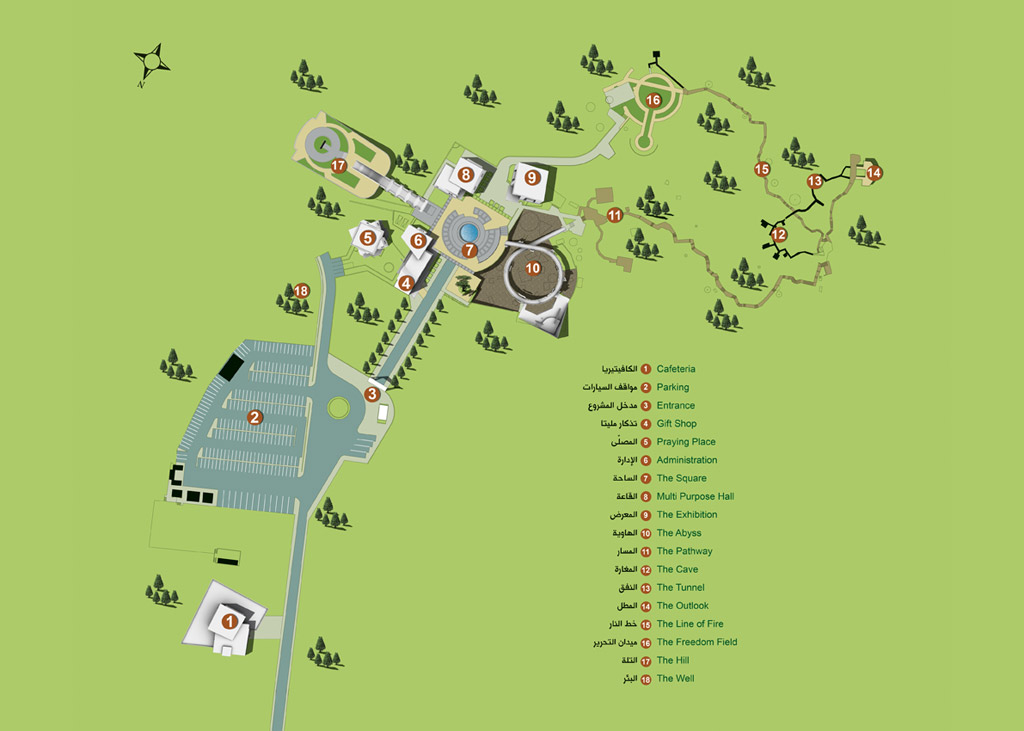
Map
back
to top |
|
1.
Cafeteria
2.
Parking
3.
Entrance
4.
Gift Shop
5.
Praying Place
6.
Administration
7.
The Square
8.
Hall Room
9.
The Exhibition
10.
The Abyss
11.
The Pathway
12.
The Outlook
13.
The Line of Fire
14.
Freedom Field
15.
The Hill
16.
The Well

|
|
Landmark Emblem
back
to top |
|
The concept of the emblem of Mleeta-Tourist Landmark of the
resistance focuses on the kind of relationship and bond between the land and the
heavens. This relationship has been expressed in a lettered,
spontaneous, confident, strong and vivid graphical way.
kind of relationship and bond between the land and the
heavens. This relationship has been expressed in a lettered,
spontaneous, confident, strong and vivid graphical way.
The Arabic word “Mleeta مليتا” is central in the emblem
between its two lower dots (symbolizing the land), and its
two upper dots (symbolizing the heavens). The predatory
sparrow hawk, colored in red, was chosen for the emblem.
This bird is obstinate, confident and restless. It does not
accept defeat or withdrawal. Its flesh is bitter and
inedible just like the fruit of the oak tree. The features
of the lines are clearly visible in the calligraphy of the
graphic artist “Masoud Nejabati” Using Arabic and Latin
letters, the lines are descended in order to ascend,
expressing mountains and sublimity coupled with earthen
colors (green and brown), mirroring the colors of life and
earth, and corroborating the fact that Mleeta is a narrative
place where the land speaks to the heavens.
|
|
Architectural Concept
back
to top |
The architectural concept in Mleeta belongs to an advanced
school of building structure. It holds a challenge regarding
the structure of its oblique walls and sloped ceilings,
which mimics the spirit of challenge that the resistance
stores, drawing a new and unique reality. The architectural
concept of the buildings in Mleeta was based on mimicking
the experience of the resistance fighters in relation to
their methods, which they adopted in building their concrete
barricades and entrenchments coupled with their ways of
camouflage and military cover. This issue made the landmark
more attached to the experience it is mimicking and more
spontaneous in resemblance. Therefore, the shapes of the
buildings with their openings and earthly colors became
congruent with their surrounding rocks, soil and trees.
Hence, the edifice in that place became part of the land’s
rocks, inflexible with its size, motivated by its wavy
lines, and proudly rising like the mountain and its rocks in
Mleeta. They are building structures with oblique walls and
ceilings through which the sunlight breaks through to
produce shadows that are mixed with glassy green color like
the trees, surrounded by bronzy colors, similar to tree
trunks.
The design and engineering of the building structures in
Mleeta are based on:
- The square that stands for the relentless plane.
- The equilateral that stands for balance, constancy and
support.
- The four sides that symbolize sunrise and sunset as well
as the trip from north to south.
- The edifice of the beginning, shelter and resting
Mleeta also tells the story of the square and the four
sides, where we can find the sunrise (rise) of the
resistance fighters and the sunset (fall) of the occupiers.
It is a trip of the land’s children of the entire homeland,
north to south. It is a continual movement that constantly
searches for the warmth of life, pride and dignity. It is a
story of firmness and adherence to the land and equality in
freedom. It is the story of shelter and residence in an
underground primitive structure. From beneath the land the
story begins. There are tunnels and rooms that embrace the
resistance fighters, with topographic land above, stubborn
and mighty with bushy trees. It resembles the rock,
compacted like the shield. It is a cold wind that blows a
whistling promise, forcing fear into the hearts of the
usurpers. It is the spirits of the martyrs, fragranced,
white in color, and moving sprightly along with the fog of
the valleys with each sunset and sunrise.
The main assembly field is squared with a size of 1500 m2,
centered by a pool of water with circling stairs along which
runs the water that fountains from above, symbolizing the
generosity of the land towards its children and vise versa.
To the right, there is a square with an olive tree in the
center, which has been rising with pride, like its owners,
striking root in the land since hundreds of years.
At the axis of the pool and field, a straight line
penetrates from the west, where there is a large hall in the
ground, which was named the abyss. It expresses sunset
(absence) and fall of the occupying invaders. It was built
on a ground of almost 3000 m2, with models, scattered all
over it, of the enemy’s destroyed vehicles, artillery and
bombs. It was composed in the form of a combined panoramic
scene, fortified by broken and oblique walls of concrete,
bearing a spiral walk that takes the visitor from the field,
through a scenic walk from above the abyss, to the entrance
of the path, a place where the Mujahidoon used to garrison.
On the other side towards the east, there is a set of
stairs, made of the land rock, that leads to top,
penetrating two masses of concrete, which form a couple of
terraces that overlook Mleeta from above, in a beautiful
panoramic scene, which was named the hill. It reaches 2000
m2 in size, interlaced by paths and spaces that are tiled
coupled with green and rosy gardens, embracing in its center
a mural of crystal. The crystal wall was engraved with
words, a special tribute to the resistance martyrs,
symbolizing martyrdom and sacrifice.
The praying place on the other hand holds in general an
architectonic feature in the form of a traditional mosque
coupled with two interlacing squares of oblique walls that
form an octagonal star. It also homes an equally divided
hall that can occupy 250 servants of God, of both men and
women with two separate entrances.
The exhibition building rests to the south west of the
field, the structure of which opens towards the field
through a columnar glassy corner in the form of slopping
partitioned spaces that harmonize with the walls. It holds
two gates, one for entry and another for exit. It also holds
concrete closets of military feature, sinking tightly within
glassy spaces, whereas its simple and vitreous show windows
exhibit samples of the spoils of war that were gained from
the enemy on battlefields, where the resistance fought
against the Israeli occupation. The gallery hall homes in
the center and in front of the entrance a hall in the
ground, half-circled concrete with several levels,
surrounded by vitreous abutment, where huge spoils of war
are exhibited directly on the floor or dangling from the
ceiling. The concrete area between the closets and the hall
holds a set of glassy closets with different sizes,
exhibiting medium and small sized spoils of war in addition
to another set of drawings and information that define the
enemy army. At the ceiling, illumination is distributed
through a meshed system of circles and squares made of
aluminum, bronze in color. Its simplicity completes the
scenic picture that depends entirely on the shapes of the
spoils of war and their colors without being overwhelmed by
any decorations.
In general:
- The architectural and tourist ideas and visions took 9
years.
- More than 50 engineers of different specialties
participated in building Mleeta landmark.
- Almost 90 outsourcers of different architectural fields
took part in executing the project.
- Forty kinds of building experts participated in different
structures.
- Execution took two years of incessant hard work.
- The project took 150000 working hours.
|
|
| Geographic Location
back
to top |
|
Mleeta Site is located in A'mel
Mountain in South Lebanon, some 1050 meters above sea level,
surrounded by the villages of Habboush, Jarjou’, Mleekh, Al-Luwaiza,
Jbaa’, and Ain Buswar. Mleeta is also surrounded by
mountainous terrains nestling the remains of kings and
Prophets of the past. From its elevation, the site overlooks
the villages of the Iqlim Al-Tuffah district, Sujud hilltop
and part of the shoreline of the Mediterranean Sea.
Mleeta is a naturally beautiful rugged
mountainous terrain covered by oak and birch trees and
characterized by its rock cavities and natural caves. The
mountain spreads over 600 000m2, and excavations
have revealed ancient tombs, broken pottery and ancient
lanterns.
Mleeta site is 82 km from Beirut, the
capitol, 37 km from the city of Saida, and roughly 90 km
from the Lebanese-Syrian ‘al Masnaa’ border point, and 188
km from the borders with occupied Palestine.
Mleeta site can be reached using the
following routes:
From Beirut:
BeirutàSaidaàZahraniàZiftaàHabboushàArabsalimàJarjouàMleeta
9th optimal route for busses and vehicles)
Or BeirutàSaidaàHaret
SaidaàKfarhattaàKfarmilkiàKfarfilaàJbaa’àAin
BouswaaràMleeta
From Syria through Masnaa
Crossing Point:
MasnaaàShtouraàQib
EliasàSughbinàMashgharaàAin
el TiniàMaydounàKfarhounaàJizzineàBkasineàJbaaàAin
BuswaaràMleeta
|
|
Summary
back
to top |
|
A Historical Abstract
Ancient history records that the word Mleeta is of Syriac
origin. It means filled up, a place where water overflows.
Perhaps the hill was given this name due to the fact that
water flows over the rocks and along the soil during spring
and summer. Hence, the area seems to be filled up with
water.
Mleeta name was also given to several regions in the
countries of Sham (currently Syria, Lebanon and Palestine),
especially near Gaza, south Palestine. Remarkably, any area
named after Mleeta is a watery area.
Modern history states that Mleeta, as a land and place, has
a tale whose chapters began in 1982 until the year of 2006.
It is a part of a general story, the story of the resistance
throughout history and the very time. In other words, Mleeta
is one of the heroes of the story and the resistance, a
march towards freedom and a combat against the Israeli
enemy, as it is the surrounding and embracing area of the
resistance. The tale of Mleeta identifies with the general
story so that both can produce in the end one integral and
harmonized tale that expresses an example of the war of
wills that ever existed between the Islamic resistance and
the Israeli enemy through human events and meanings that
truly took place in Mleeta.
In 1982, the Israeli enemy army occupied Mleeta during its
invasion of Lebanon as well as occupied Beirut capitol to
withdraw from it in 1985. The enemy’s first retreat was the
fruit of resistance operations to withdraw behind what was
renowned later as the buffer zone, where the enemy
entrenched itself in several military outposts, stretching
from Hasbaya east to Naqoura west.
In late 1985, the first group of the resistance resorted to
Mleeta as a centralized shelter and stronghold, facing enemy
outposts in Sujud and Be’r Kallab. Mleeta was also a bridge
for the Mujahideen to execute military operations against
enemy soldiers in the highlands of Nabatiye, Iklim al Tuffah
and West Biqaa.
In early 1986 until 2000, Mleeta became a strategic military
outpost for the resistance and throughout the period of the
occupation the enemy tried repeatedly to occupy and burn it
down, but it failed. The enemy’s persistence was due the
fact that the fall of Mleeta into the hands of its soldiers
would mean the fall of the resistance back lines in the
villages of Loueize, Ein Bouswar, Jebaa and others. The
gravest issue was the besieging of Safi Mountain, the
largest and main stronghold of the resistance at that epoch.
Therefore, to prevent the penetration of Mleeta, the Islamic
resistance Mujahideen came from all parts of the region with
the surrounding neighborhoods, aided by some residents, in
order to transform Mleeta into a strong fort and a hot line
of defense. They succeeded through the unity of the will and
faith with the elements of nature such as trees, rocks, soil
and caves.
Throughout the years of conflict, the enemy was never able
to cross Mleeta. Instead, Mleeta became a special Jihadi
academy with special spirituality that recruited thousands
of resistance fighters. It also became a bridge for the
Mujahideen to execute military operations inside the
occupied zone. Hence, Mleeta played a defensive role with
another offensive at the same time.
In a few words, Mleeta is a story of a fort that was built
by a special kind of people. It was paved with non material
stones, which were extracted from the mine of patience, free
will and absolute faith in Allah the exalted. It was raised
by the pillars of the martyrs, the wounded and good people
to become a story, which the land reads to the heavens (the
land speaks to the heavens).
|
| General Informatio
back
to top |
1. Mleeta site opens daily from 10 am to 9 pm
2. Touring the site generally takes between 60 to 120
minutes
3. The site contains panels explaining all scenes and
listing all divisions in Arabic and English
4. The Site is run by a specialized team that will insure
the safety and comfort of visitors
5. The site has a group of tour guides proficient in
English, French, Spanish, Persian, German, and Arabic. Their
services are free-of-charge.
Notes for Visitors:
1. Visitors are kindly requested to be appropriately dressed
for the site. A hat and sunscreen are advised during summer.
2. Smoking is prohibited, especially in the bushy areas.
3. Strollers are not allowed in the bushy areas due to the
rugged terrain.
4. Cleanliness is a must; therefore, rubbish must be
discarded adequately.
|
|
|
|
|
|
|